Satellite Eye on Earth:  Eastmain-1-A/Sarcelle/Rupert Project in Quebec, east of James Bay, Canada
A work in progress in northern Quebec, east of James Bay. The project - known as the Eastmain-1-A/Sarcelle/Rupert Project - is designed to increase hydro-electric power for the Canadian province. This image is a wide-area view of the project, and it shows the Eastmain reservoir, which lies about 800km (500 miles) north of Montreal. A layer of ice lingers on the reservoir's surface, with areas of open water appearing in darker shades of blue. Cracks on the ice span the reservoir, especially in the south Photograph: ALI/EO-1/NASA
Satellite Eye on Earth:  island of Crete
In classical Greek mythology, the island of Crete was home to King Minos and the terrible Minotaur, a beast that was half man and half bull. The known historical record of Crete is no less impressive. The island was the centre of the Bronze Age Minoan civilisation that flourished from approximately 2700–1420BC. There is archaeological, geological, and cultural evidence to suggest that a cataclysmic volcanic eruption around 1620BC was a major cause of the decline - if not complete destruction - of the Minoan civilization. Today, Crete is the largest and most heavily populated island of Greece. The island stretches approximately 260km from west to east, and it is roughly 60km across at its widest point. The largest city on the island, Heraklion, sits on the northern coastline. Several smaller islands ring Crete. Two of the largest of these, Dia and Gavdos, are sparsely populated year-round, although Gavdos hosts numerous summer visitors Photograph: ISS/NASA
Satellite Eye on Earth: This satellite image shows Lake Sulunga in central Tanzania
This satellite image shows Lake Sulunga and surrounding areas in central Tanzania. A major road running east to west can be seen north of the lake with a railway running nearby. Agriculture is evident in the surrounding areas. This semi-arid area of the country experiences frequent droughts Photograph: ALOS/JPL/ESA
Satellite Eye on Earth: Chile’s Puyehue-Cordón Caulle Volcanic Complex
Months after first erupting and sending ash around the world, activity at Chile’s Puyehue-Cordón Caulle Volcanic Complex may be winding down. The volcanic plume - seen near the top of this satellite image - appears noticably thinner than it did one week earlier Photograph: MODIS/Aqua/NASA
Satellite Eye on Earth: Franz Josef Land in the northeastern Barents Sea, Russia
Russia's northernmost territory, Franz Josef Land, is an archipelago of 191 islands in the north-eastern Barents Sea. Clouds fringe this natural-colour image, and sea ice forms serpentine shapes of light grey and dull white around the islands. The glaciers that cap many of the islands are bright white. In ice-free areas, land cover is pale brown, typical of tundra Photograph: MODIS/Terra/NASA
Satellite Eye on Earth: Hurricane Eugene
This image of the eastern Pacific Ocean shows Hurricane Eugene (right) off the western Mexican coast on 2 August Photograph: NOAA GOES Project/NASA
Satellite Eye on Earth: Hurricane Irene
Hurricane Irene captured on a satellite image on 26 August. More than 40 people were killed when Irene lashed the eastern seaboard from the Carolinas to Maine. Despite being downgraded to a tropical storm as it hit land, Irene destroyed many homes and caused serious flooding in Vermont and upstate New York. The damage will cost $1.5bn in disaster relief, the White House has estimated Photograph: NOAA GOES Project/NASA
Satellite Eye on Earth: Liverpool Bay in Canada’s Northwest Territories
The land around Liverpool Bay in Canada’s Northwest Territories owes its otherworldly appearance to ice, both past and present. Thousands of years ago, this area was buried under a massive ice sheet that sprawled over much of North America. During that time, glacial activity carved out parallel lakes separated by strips of land that look like giant skeletal fingers. After the glaciers retreated, pockets of ice lingered underground. As those pockets have melted and the frozen ground has thawed, lakes have formed, in a region east of Alaska, along the Beaufort Sea. The area includes part of Liverpool Bay, the Eskimo Lakes, and the Tuktoyaktuk Peninsula. Tundra overlies permafrost around Liverpool Bay, but at this time of year, the nearby ocean is free of sea ice, and little if any snow is on the ground. This image has been rotated so that north is on the right Photograph: Landsat 5/NASA
Satellite Eye on Earth: Northern Sea Route , Arctic
North of Russia, the northern sea route (also known as the north-east passage) is open to shipping traffic. This image shows the Severnaya Zemlya archipelago surrounded by open water Photograph: MERIS/ESA
Satellite Eye on Earth: Omulyakhskaya and Khromskaya Bays, Russia
Omulyakhskaya and Khromskaya Bays lie along the northern Siberian coast, south-east of the Lyakhov Islands. The northerly location almost guarantees ice in the adjacent East Siberian Sea, and permafrost blankets the land around the bays. When ice lingered on the sea surface and on some inland water bodies. The land around the bays is dotted with thermokarst lakes, which result from water released by thawing permafrost. Lacking drainage, the melt water accumulates, forming small lakes. Although far too cold for a pleasant dip, the water in these lakes is generally warm compared with the surrounding frozen ground. Because thawing permafrost and thermokarst lakes release carbon and methane – both greenhouse gases – scientists monitor these landscapes closely because of their implications for future climate Photograph: Landsat 5/NASA
Satellite Eye on Earth: Southern Namibia and northern South Africa
Southern Namibia and northern South Africa on Africa’s lower-west coast. We can clearly see the sand dunes of the Namib Desert – considered to be the oldest desert in the world. To the south of the desert is the Sperrgebiet diamond mining area. Further south, the Orange river forms part of the border between South Africa and Namibia before emptying into the Atlantic Ocean at Alexander Bay, which is noticeable by a lighter green colour in this image Photograph: Envisat/ESA
Satellite Eye on Earth: The Betsiboka estuary in northwest Madagascar
The Betsiboka estuary in north-west Madagascar is pictured in this image. Here, the country’s largest river flows into Bombetoka Bay, which then opens into the Mozambique Channel. The red colouring of the sandbars and islands between the 'jellyfish tentacles' comes from sediments washed from hills and into the streams and rivers during heavy rain. The seaport city of Mahajanga can be seen in the upper-left corner of the image Photograph: ALOS/JPL/ESA
Satellite Eye on Earth: Amazon
The skies over the Amazon were relatively free of clouds and only lightly covered with haze on 31 July when the Terra satellite passed over the region, capturing this true-colour image of verdant green forests interrupted by a broad swath of deforestation Photograph: MODIS/Terra/NASA
Satellite Eye on Earth:  Taklimakan Desert in China.
In westernmost China lies the Tarim Basin, home to the Taklimakan Desert – the biggest, hottest, driest desert in China. Sand dunes cover about 85% of the Taklimakan, often feeding massive dust storms. Isolated from the Asian monsoon and from Arctic storms, the central basin receives less than 10mm of precipitation a year. In such a parched environment, plants are rare. In the summer, they appear to thrive. Along the basin's northern margin, the Hotan joins the Tarim river, which links multiple areas of green in the August image. The Tarim river supplies water to an area roughly 500km long. Deciduous forests, filled with poplar trees, flourish nearby in the summer. The forests not only green up the edges of the Tarim Basin, they also stabilise the sandy soil and moderate the arid climate. As human settlement in the region has increased, however, some of this forest has been cleared to make way for irrigated crops Photograph: MODIS/Terra/NASA
Satellite Eye on Earth: The phytoplankton bloom  stretches across the Barents Sea
The phytoplankton bloom stretches across the Barents Sea off the coast of mainland Europe’s most northern point, Cape Nordkinn. Although most types of phytoplankton are individually microscopic, the chlorophyll they use for photosynthesis collectively tints the colour of the surrounding ocean waters Photograph: MERIS/Envisat/ESA
Satellite Eye on Earth: Two great lagoons to the north and south of Kaliningrad, Russi
Two great lagoons to the north and south of Kaliningrad, Russia. A broad arm of agricultural country separates the freshwater lagoons – Vistula Lagoon and Kurshsky Bay (which is known as the Curonian Lagoon in nearby Lithuania). Each is protected from the open waters of the Baltic Sea by the thin, perfect curves of current-generated sand spits. The camera settings used to acquire sunglint images result in high contrast, which reveals the fine detail of coastlines and surface features of water bodies, while masking land surface details. The thin canal leading from the Baltic to Kaliningrad is visible, but the great port of Kaliningrad itself is not. Other human patterns on this intensively developed landscape – such as towns, highways and farm boundaries – are likewise masked Photograph: ISS/NASA
Satellite Eye on Earth: cities of northwestern Europe at night
Several of the oldest cities of north-western Europe are highlighted in this photograph from just after midnight on 10 August. While the landscape is dotted with clusters of lights from individual urban areas, the metropolitan areas of London, Paris, Brussels, and Amsterdam stand out. The metropolitan area of Milan is also visible at image upper right. The image is oblique – taken looking outwards at an angle, which tends to foreshorten the image – making the distance between Paris and Milan appear less than that of Paris to London Photograph: ISS/NASA
Satellite Eye on Earth: flooding in Cambodia
In August 2011, floods extended from Cambodia's Tonle Sap southward past Phnom Penh. The Phonm Penh Post reported that unusually heavy rainfall over the upper Mekong river in Laos and Thailand led to severe flooding in Cambodia. Vegetation is green, and clouds are pale blue-green. Water ranges in color from navy to silver-blue. The silver tones of the water result from sunlight reflecting off the water surface. This region experiences persistently cloudy weather, but regardless of some cloud cover, significant changes are apparent between August 2010 and August 2011 Photograph: MODIS/Terra/NASA

The GuardianTramp

Related Content

Article image
Satellite eye on Earth: June 2012 – in pictures

A rainbow-like 'glory', wildfire clouds and Africa's highest mountains

05, Jul, 2012 @10:33 AM

Article image
Satellite eye on Earth: October 2012 – in pictures

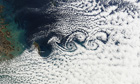
Cloud vortices, salt flats, superstorms and desert wetlands were among the images captured by European Space Agency and Nasa satellites last month

09, Nov, 2012 @6:00 AM

Article image
Satellite eye on Earth: September 2011 - in pictures

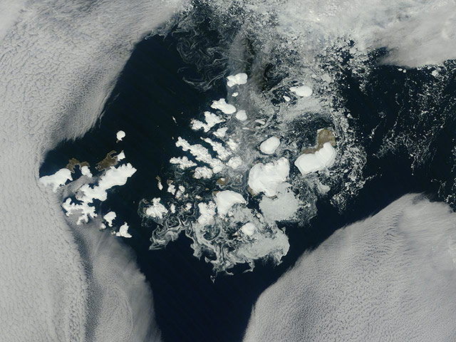
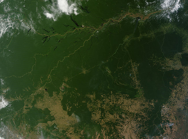
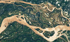
Ice islands in the Atlantic, blocked river valleys in Pakistan and salt lakes in the outback were among the images captured by Nasa satellites last month

10, Oct, 2011 @11:56 AM

Article image
Satellite eye on Earth: June 2011 - in pictures

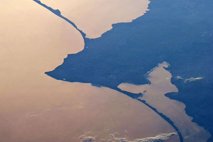
Barrier islands in Brazil, volcanic ash clouds in Chile and mineral mining in China were among the images captured by Nasa satellites last month

12, Jul, 2011 @10:55 AM

Article image
In pictures: Satellite eye on Earth - December 2009

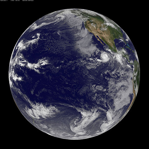
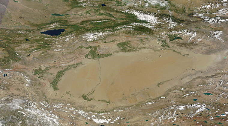
Record-breaking snow storms, anticyclone cloud formations and sculpted sand dunes were among the images captured by Nasa satellites during December

04, Jan, 2010 @12:14 PM

Article image
Satellite eye on Earth: January 2014 – in pictures
A milky blanket shrouds North America as it feels the Arctic chill, cloud bands form patterns over the red landmass of Mauritania and world's tallest peaks sit as tiny dots over soaring Himalayas in images captured from space last month

03, Feb, 2014 @1:18 PM

Article image
Satellite eye on Earth: January 2013 - in pictures

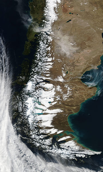
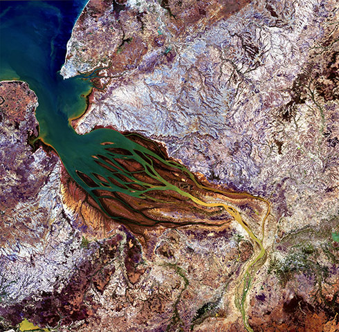
Grinding glaciers, serpentine cloud shapes and snow-covered deserts were among the images captured by European Space Agency and Nasa satellites last month

12, Feb, 2013 @7:00 AM

Article image
Satellite eye on Earth: February 2011 - in pictures

Pollution over Bangladesh, severe winter storms and a heart-shaped coral atoll were among the images captured by Nasa satellites last month

02, Mar, 2011 @3:21 PM

Article image
Satellite eye on Earth: May 2011 - in pictures

Tornadoes in the US, volcanoes in Iceland and fires around the globe were among the images captured by Nasa satellites last month

07, Jun, 2011 @1:48 PM

Article image
Satellite eye on Earth: November 2012 – in pictures

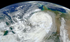
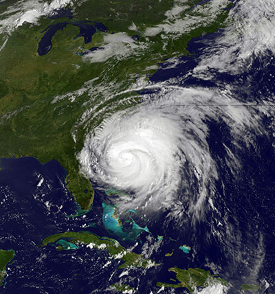
Volcanoes' snow-covered peaks, India lit up by Diwali lights, and damage from superstorm Sandy were among the images captured by European Space Agency and Nasa satellites last month

10, Dec, 2012 @12:26 PM